Gletscher und Schluchten

Gletscher und Schluchten

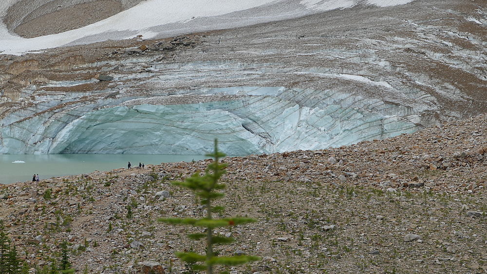
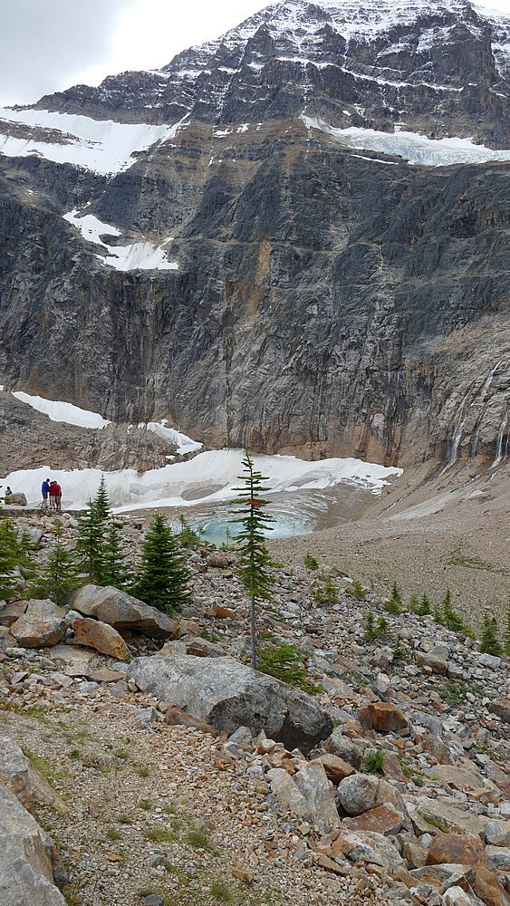
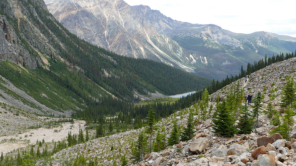
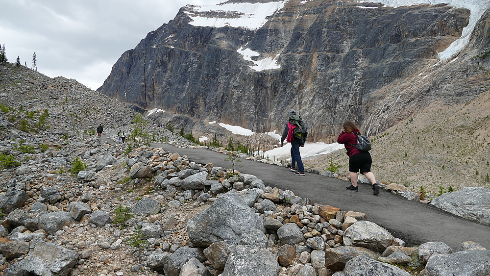
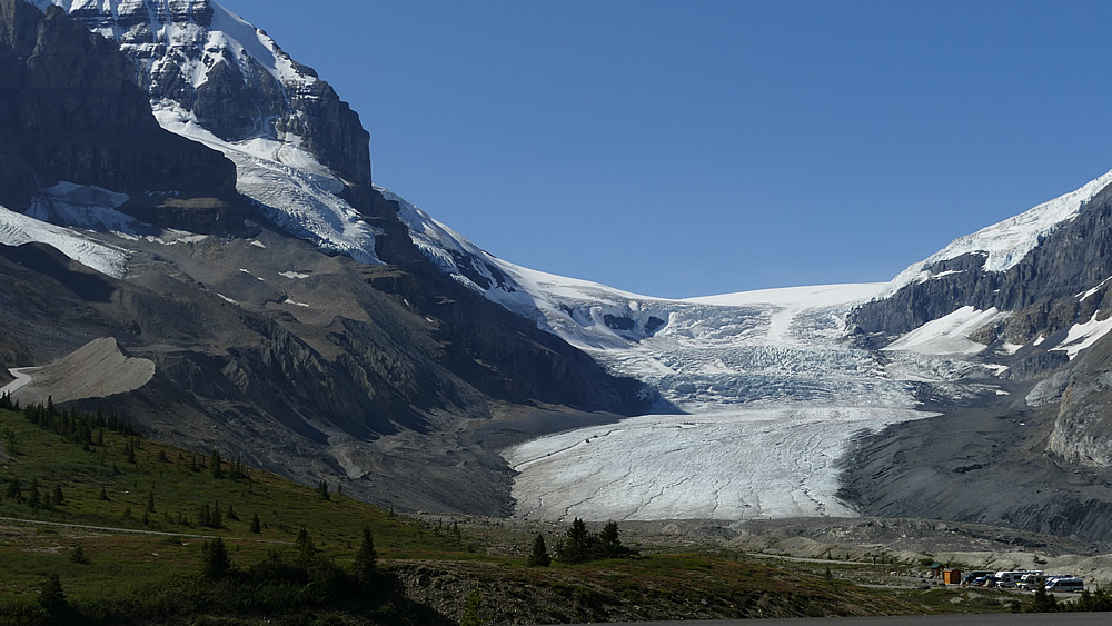
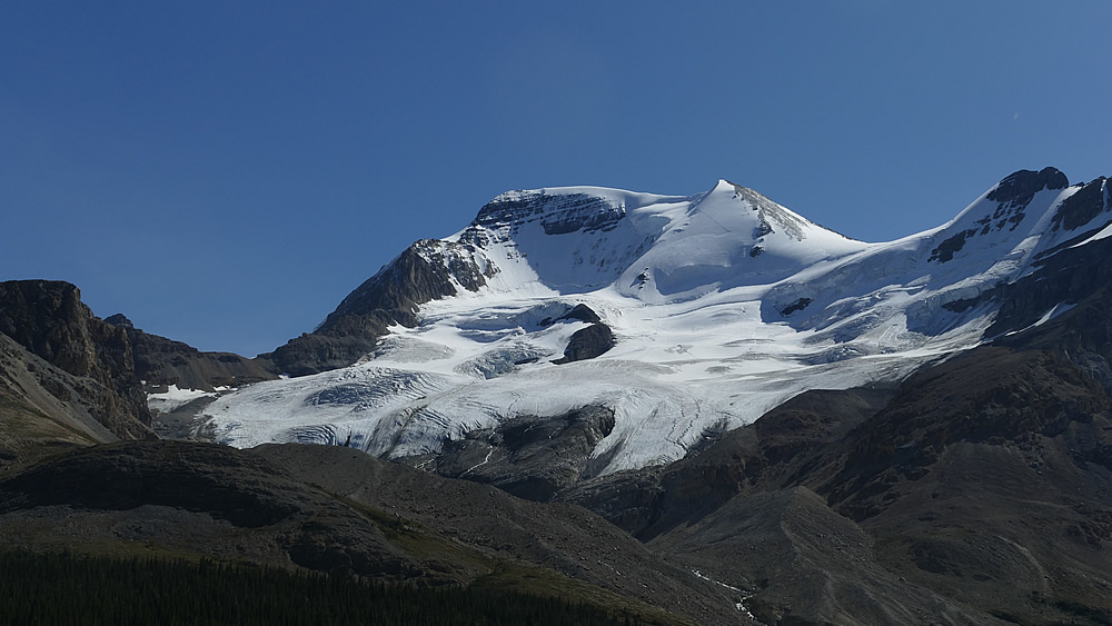
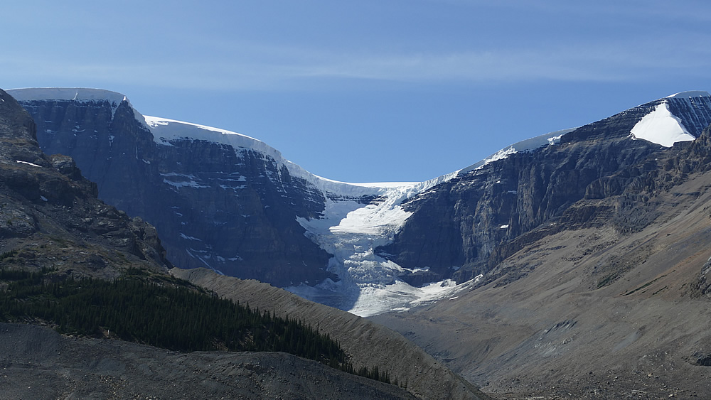
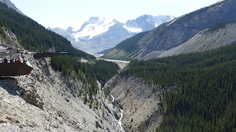
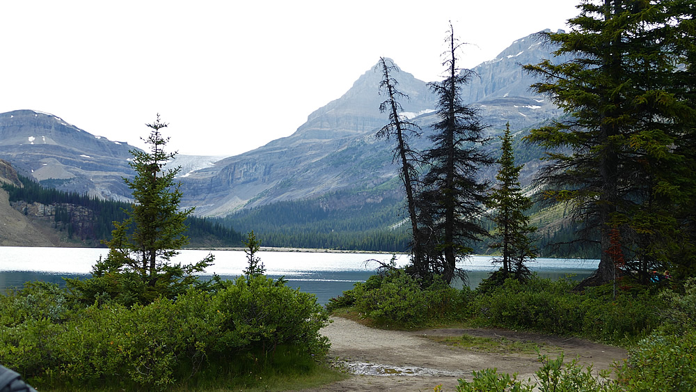
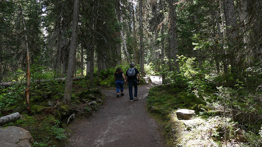
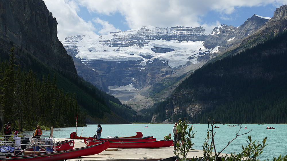
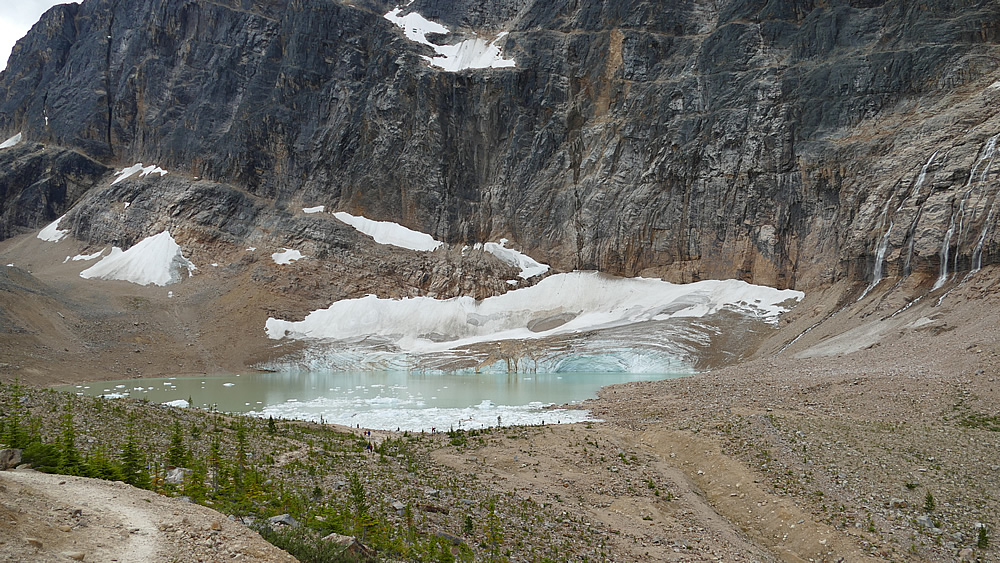
Heute entscheiden wir uns für die Wanderung zum Mount Edith Cavell. Dort soll ein einfacher Wanderweg zu einem alpinen Gletschersee führen. Zunächst geht es gut 15 km eine Serpentinenstraße hoch in die Bergregion. Soweit oben waren wir bisher noch nie. Wir sind keine versierten Wanderer und möchten uns in unserem Urlaub auch nicht beim exzessiven Wandern und Überwinden von Höhenmetern verausgaben. Erleben, sehen, wahrnehmen, das Hier und Jetzt genießen und natürlich schöne Erinnerungsfotos schießen stehen im Vordergrund. Der Weg ist also genau richtig für uns. Er geht ein ziemliches Stück bergauf aber nach recht kurzer Zeit, vielleicht 30 Minuten, sind wir auch schon da. Wir sind jetzt in einer richtig alpinen Region, oberhalb der Baumgrenze angelangt.

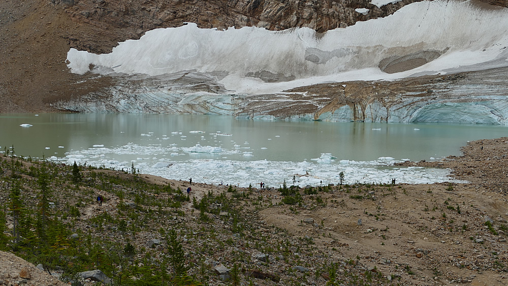
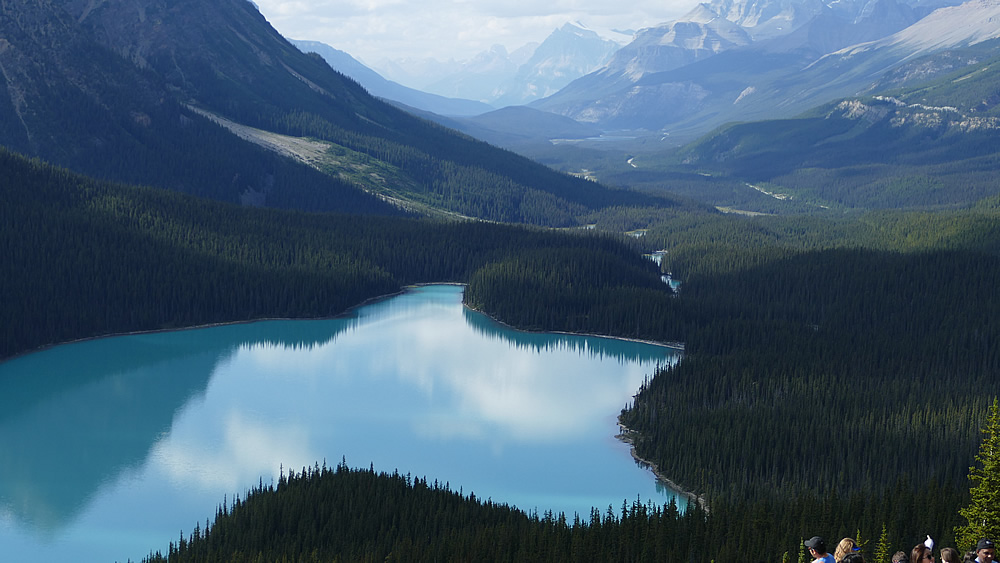
In diesen Regionen haben wir uns bisher selten bewegt. Der Blick auf den See ist ein bisschen gespenstisch. Eine türkis-weiße Fläche in grau-braunen Gestein, gefüllt mit großen Eisschollen. Das ist mal ganz was anderes. Wir genießen den Ausblick auf den See und den Gletscher oberhalb und machen uns nach einiger Zeit wieder an den Abstieg.

Der Wanderweg ist beliebt. Fast zuviel Leute sind mal wieder auf dem selben Weg unterwegs. Ich bin immer wieder verblüfft, dass auch viele ältere, schon ziemlich gebrechliche Paare hier unterwegs sind und solche Strapazen auf sich nehmen.

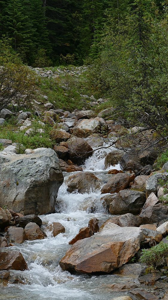
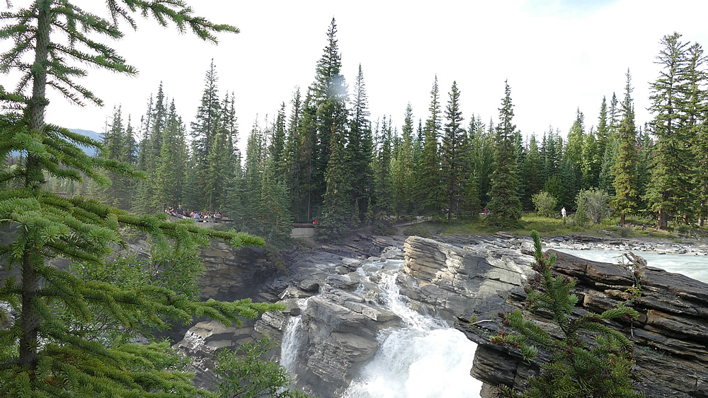
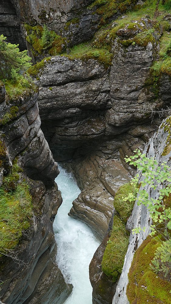
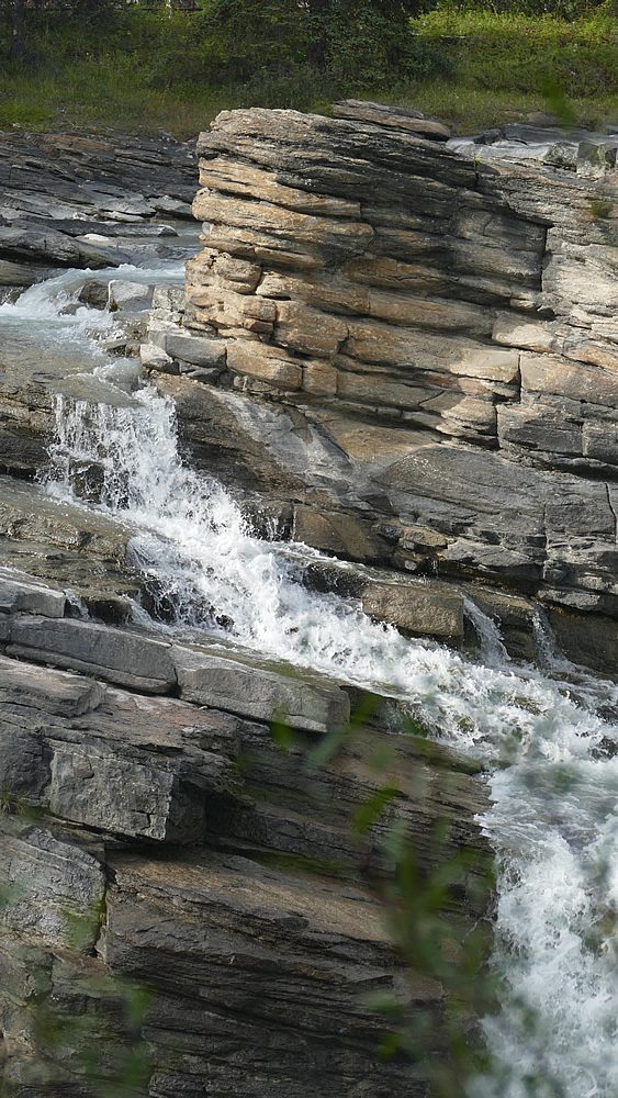
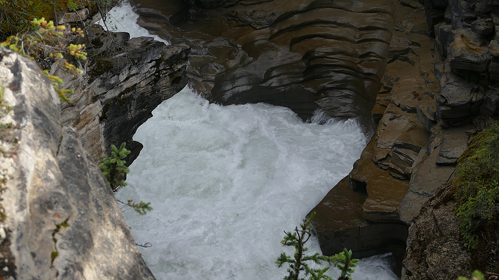
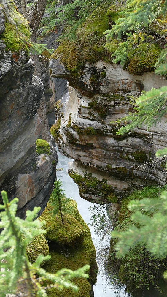
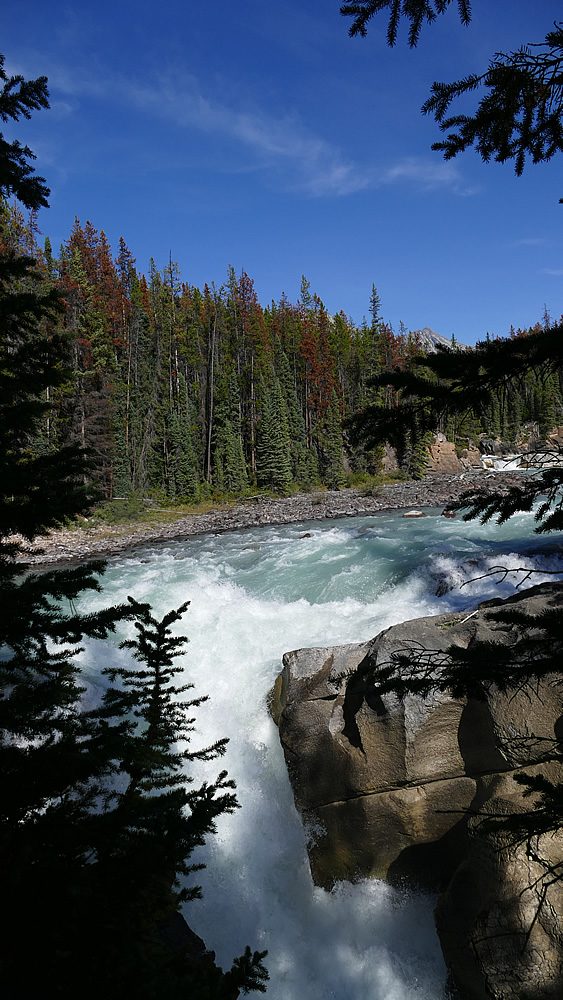
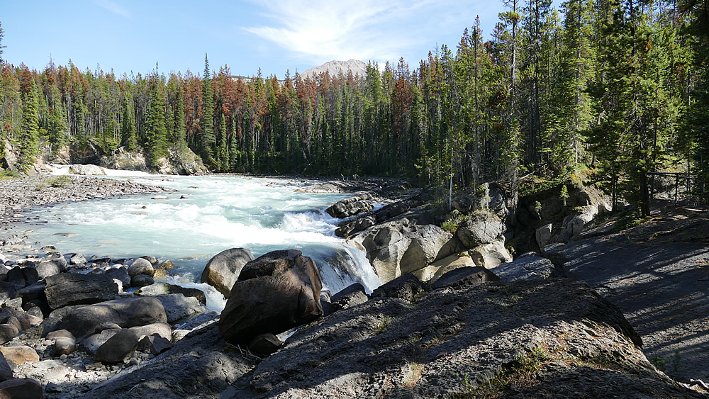
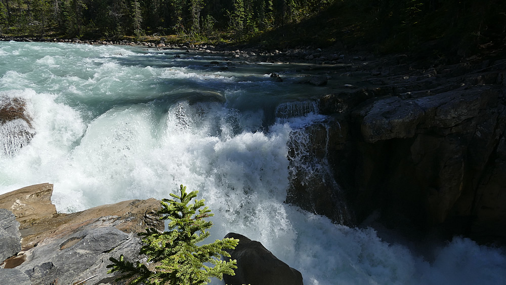
Als nächstes ist ein spektakulärer Canyon, der Maligne Canyon auf dem Plan. Der Canyon ist ca. 50 Meter tief und stellenweise nur 2 Meter breit. Über den Canyon gehen mehrere Brücken, die man sich alle erlaufen kann. Wir genießen die Wanderung entlang des Canyons und schießen jede Menge Fotos.

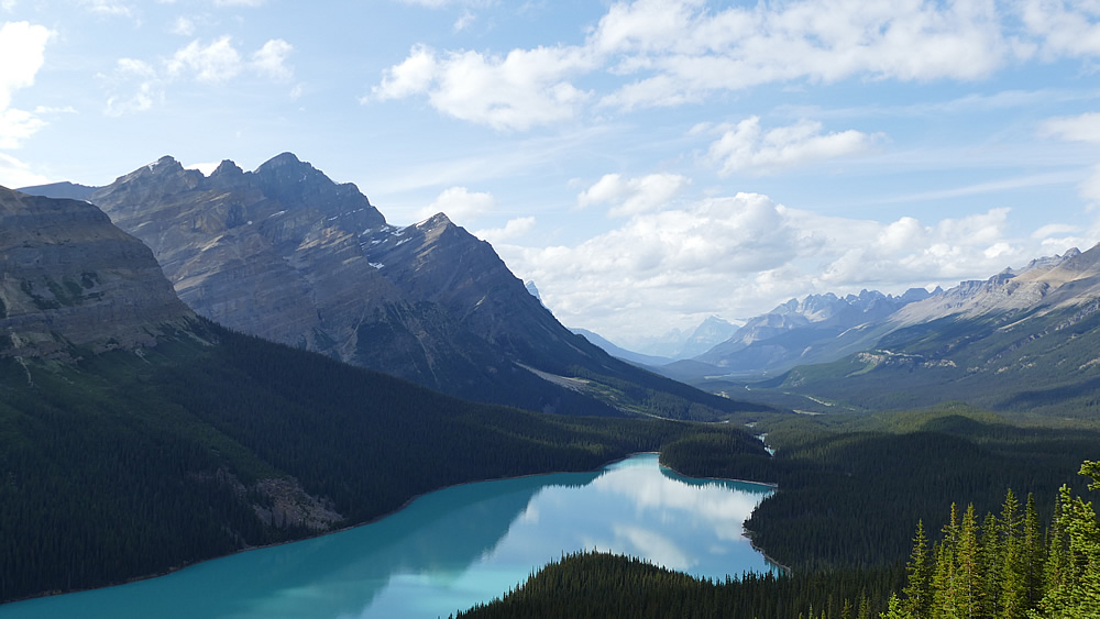
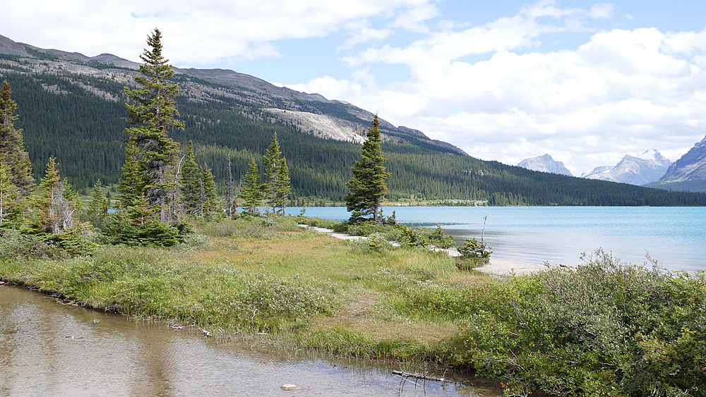
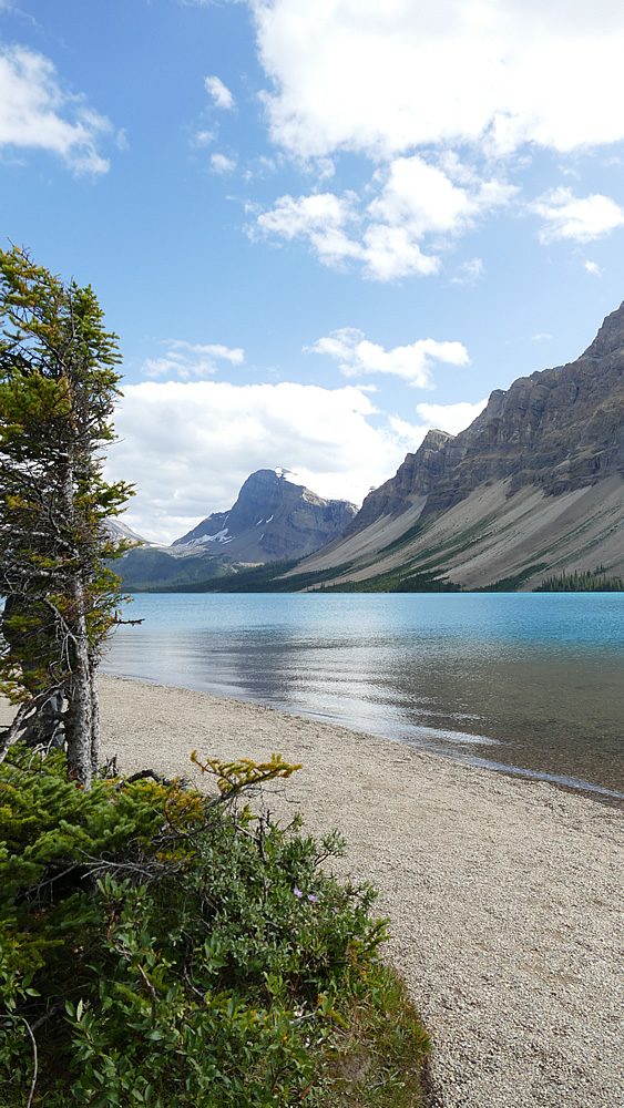
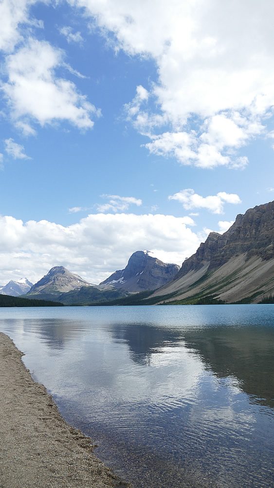
Am Nachmittag fahren wir ca. 45 km das Tal hoch zum Maligne-Lake. Hier soll es Bootsfahrten und Kanufahrten geben. Darauf hätten wir jetzt so richtig Lust. Außerdem möchten wir gerne den Abend dort am See verbringen und picknicken. Aber … daraus wird nichts. Der Himmel zieht sich mehr und mehr zu und es regnet. Bisher hatten wir mega Glück mit dem Wetter. Heute klappt es nicht mit der Kanutour und das Picknick fällt ins Wasser. Die Kanutour möchten wir aber auf alle Fälle noch irgendwo machen. Wir werden nach Möglichkeiten Ausschau halten.

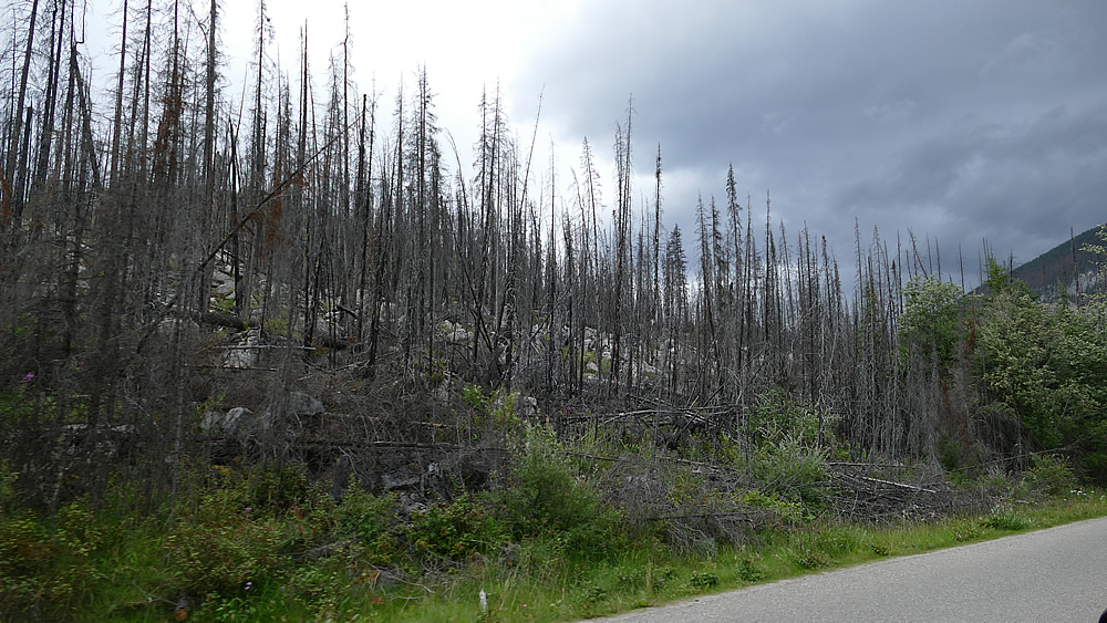
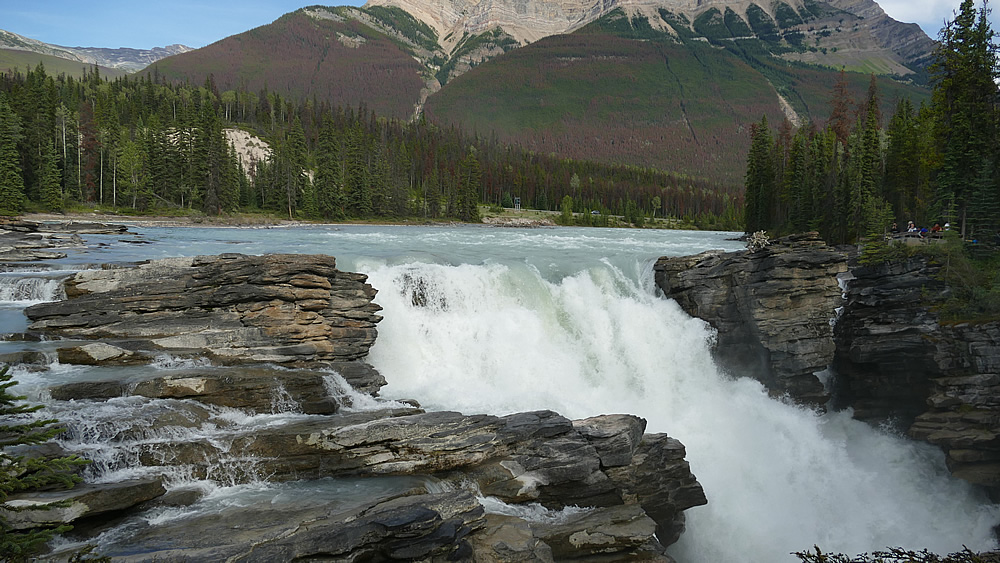
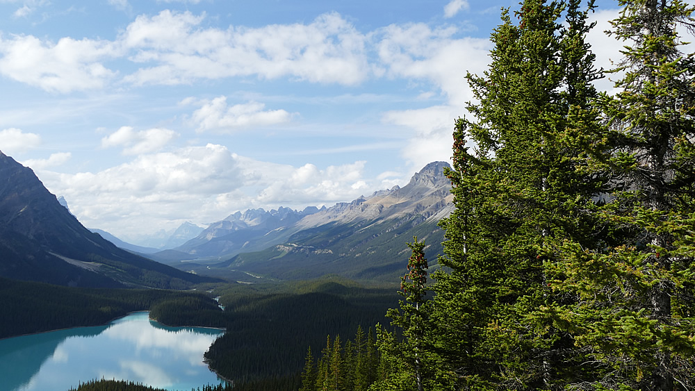
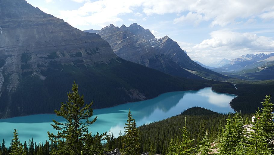
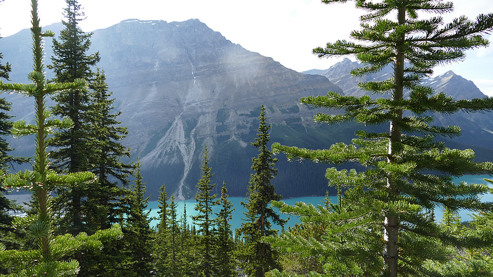
Der Rückweg zieht sich ziemlich. Wir fahren am Medicine Lake vorbei, hier ist hängeweise Wald abgebrannt. Das sieht unheimlich aus. Trotzdem bieten sich immer wieder wunderschöne Blicke auf die einmalige kanadische Rocky-Landschaft.

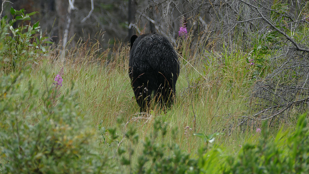
Von weitem sehe ich schon, dass wieder Autos am Straßenrand stehen und sich eine kleine Ansammlung Menschen am Straßenrand tummeln. Da wird doch nicht wieder ein Bär unterwegs sein? Tatsächlich, auf der linken Straßenseite wandert ein Schwarzbär entlang auf der Suche nach Fressbarem. Wir halten an und ich steige mit der Kamera bewaffnet aus. Aber oh mein Gott, der Bär dreht seine Richtung und läuft genau auf unser Auto zu! Schnell steige ich wieder ein, das ist mir dann doch etwas zu brenzlig.

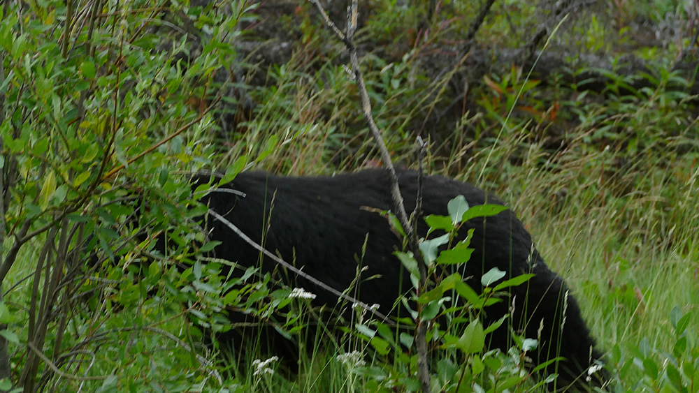
Dietmar, der Mutige steigt mit seinem Handy bewaffnet aus. Der Bär läuft am Auto vorbei die Straße entlang. Dietmar hält mit dem Handy drauf. Ich hoffe, es gibt ein paar richtig gute Fotos. Schließlich verschwindet der Bär im Gebüsch.

Ich habe ein Video gemacht, sagt Dietmar stolz und gespannt wollen wir es uns ansehen. Aber … das hätte ich mir fast denken können … vor lauter Aufregung hat Dietmar zwar den Modus auf Video geändert, aber vergessen den Startknopf zu drücken. Nichts ist’s mit dem spektakulären Bärenvideo! 😊 😊

Trotzdem, der Ausflug zum See hat sich doch noch gelohnt!

Glaciers and gorges

Today we decide to hike to Mount Edith Cavell. There a simple hiking trail is supposed to lead to an alpine glacial lake. First we go a good 15 km up a serpentine road into the mountain region. We have never been this far up. We are not experienced hikers and don’t want to spend our holidays on excessive hiking and overcoming meters of altitude. Experiencing, seeing, perceiving, enjoying the here and now and of course taking beautiful souvenir photos are in the foreground. So the way is just right for us. It goes quite a bit uphill but after quite a short time, maybe 30 minutes, we are already there. We are now in a really alpine region, above the tree line.

In these regions we have rarely moved so far. The view of the lake is a bit spooky. A turquoise-white surface in grey-brown rock, filled with large ice floes. That is something completely different. We enjoy the view to the lake and the glacier above and after some time we descend again.

The hiking path is popular. Almost too many people are on the same way again. I am astonished again and again that also many older, already quite frail couples are on the way here and take such strains on themselves.

Next on the map is a spectacular canyon, the Maligne Canyon. The canyon is about 50 meters deep and in places only 2 meters wide. The canyon is crossed by several bridges, all of which can be walked. We enjoy the hike along the canyon and take lots of photos.

In the afternoon we drive about 45 km up the valley to the Maligne Lake. Here there are supposed to be boat trips and canoe trips. We would really like that now. Besides we would like to spend the evening talking at the lake and picnic. But … nothing will come of it. The sky is closing more and more and it is raining. So far we had mega luck with the weather. Today it does not work with the canoe tour and the picnic falls into the water. The canoe tour we would like to make however in any case still somewhere. We will look for possibilities.

The way back is quite long. We drive past the Medicine Lake, where there is a lot of forest burned down. That looks scary. Nevertheless there are always beautiful views of the unique Canadian Rocky landscape.

From a distance I can already see that there are cars at the roadside and a small group of people at the roadside. There won’t be another bear on the way? Actually, on the left side of the road there is a black bear walking along in search of food. We stop and I get out armed with the camera. But oh my God, the bear turns his direction and runs right towards our car! Quickly I get back in the car, that’s a bit too dangerous for me.

Dietmar, the brave man gets out armed with his mobile phone. The bear runs past the car along the road. Dietmar holds with the mobile phone on it. I hope there are some really good photos. Finally the bear disappears into the bushes.

I made a video, Dietmar says proudly and excitedly we want to watch it. But … I could almost have imagined that … because of all the excitement Dietmar changed the mode to video, but forgot to press the start button. It’s nothing with the spectacular bear video! 😊 😊

Still, the trip to the lake was worth it!

Gletscher und Wasserfälle

Gletscher und Wasserfälle

Und weiter geht es Richtung Norden. Wir fahren den Icefield Parkway in Richtung Jasper.

Auf der Strecke liegt das Columbia Icefield. Das riesige Eisfeld ist 300 Meter dick, bedeckt eine Fläche von 325 km² und besteht aus insgesamt 12 Gletschern. Wir buchen den Skywalk, eine Aussichtsplattform mit Glasboden, die 30 Meter in das Tal ragt und einen beeindruckenden Blick auf die Gletscher ermöglicht. Insgesamt wird natürlich eine ordentliche Menge Touristen durchgeschleust und eigentlich mag ich ja solche Orte nicht wirklich. Aber alles ist sehr professionell und mit viel Liebe zum Detail aufbereitet. Eine Rangerin macht spontan eine kleine Führung und erklärt uns alles mit viel Enthusiasmus. Besonders hängengeblieben: Das Schmelzwasser der Gletscher fließt in 3 Weltmeere, den Atlantik, das Eismeer und den Pazifik und liefert einen wichtigen Beitrag zum Wasserhaushalt der Erde.

Auf der Weiterfahrt besuchen wir zwei eindrucksvolle Wasserfälle, die Sunaptwa und die Athabasca Falls. Die Wanderungen durch die kanadischen Wälder machen wirklich Spaß, der Touristenandrang ist überschaubar, so dass wir immer wieder streckenweise ganz alleine unterwegs sind.

Die Fahrt zur Lodge hat’s in sich: Nach einer langezogenen Kurve sehen wir rechts und links am Straßenrand plötzlich Fahrzeuge mit Warnblinkeren stehen. Einige Leute laufen aufgeregt am Straßenrand. Hm, was ist denn da passiert? Wir fahren vorsichtig ran! Wohoo ein großer Schwarzbär tummelt sich gemütlich am Seitenhang. Unser erster Bär! Leider kommen wir nicht allzu dicht dran und ich kann nur ein paar verwackelte Fotos schießen, schon ist er wieder im Gebüsch verschwunden.

Am Abend kommen wir in Jasper an. Jasper ist ein kleines weitestgehend auf Touristen ausgerichtetes Städtchen und bietet außer Souvenirgschäften und Restaurants nicht allzu viel. Alles hat ein bisschen Pioneercharakter.

Unsere Unterkunft in der Marmot Lodge ist ordentlich. Hier bleiben wir 2 Nächte.

And we’re heading north. We drive the Icefield Parkway in the direction of Jasper.

Columbia Icefield is on the track. The huge ice field is 300 meters thick, covers an area of 325 m² and consists of a total of 12 glaciers. We book the Skywalk, a viewing platform with a glass floor that protrudes 30 meters into the valley and offers an impressive view of the glaciers. All in all, of course, there are a lot of tourists passing through and actually I don’t really like such places. But everything is very professional and prepared with a lot of love to the detail. A ranger spontaneously makes a small tour and explains everything to us with a lot of enthusiasm. The meltwater of the glacier flows into 3 oceans, the Atlantic, the Arctic Sea and the Pacific and makes an important contribution to the water balance of the earth.

On the way we visit two impressive waterfalls, the Sunaptwa and the Athabasca Falls. The hikes through the Canadian forests are really fun, the crowds of tourists are manageable, so that we are always on our way alone.

After a long curve we suddenly see right and left at the roadside vehicles with hazard lights. Some people walk excited at the roadside. Hm, what happened there? We drive carefully! Wohoo a big black bear is romping around comfortably on the side slope. Our first bear! Unfortunately we don’t get too close and I can only take a few blurred photos, already he has disappeared again in the bushes.

In the evening we arrive in Jasper. Jasper is a small town that is mostly oriented towards tourists and does not offer too much apart from souvenir shops and restaurants. Everything has a little pioneer character.

Our accommodation in the Marmot Lodge is neat. Here we stay for 2 nights.

Lost in the woods

Lost in the woods

Von Canmore aus geht es Richtung Norden in den Banff Nationalpark. Auf unserer Liste stehen jede Menge landschaftliche Highlights Westkanadas. Als erstes geht’s zu den Upper Hot Springs, heißen Quellen, die direkt aus dem Berg strömen. Hier gibt es gleich noch eine Thermalbad, in dem sich morgens doch tatsächlich schon ein paar Touristen tummeln. Es riecht beißend nach Schwefelwasserstoff.

Weiter geht’s zum Lake Louise. Der See ist wegen seiner besonderen Wasserfärbung und der indyllischen Lage berühmt. Klar dass das ein richtige Touristenmagnet ist. Die Parkplätze sind voll, jede Menge Touristen hatten dieselbe Idee. Der See ist schön, keine Frage, aber das riesige Hotel am östlichen Ufer finden wir irgendwie total deplatziert. Der Blick von oben auf den See – das typische Fotomotive, muss natürlich sein. Wir wagen uns auf unsere erste Wanderung durch die kanadischen Wälder. Der Weg geht recht steil bergauf und ist richtig anstrengend, aber nach der ganzen Autofahrerei tut es gut, sich mal richtig zu bewegen. Der einmalige Blick von oben auf den See, ist die Anstrengung durchaus wert.

Eigentlich möchten wir nun noch den Lake Moraine besuchen. Laut Insidertipp soll der noch viel schöner und indyllischer sein. Der See und die 10 Berggipfel dahinter sind auf der alten kanadischen 20-Dollar-Note abgebildet. Aber die Straße ist für private Fahrzeuge gesperrt und alle Bustickets für den Tag sind bereits verkauft. Schade.

Weiter geht’s Richtung Norden. Am Abend haben wir eine Übernachtung beim Saskatchewan River Crossing gebucht. Auf dem Weg dahin weist die Karte zwei weitere Seen aus, die wir anfahren möchten. Wunderschön direkt am Highway liegt der Bow-Lake. Als absolutes Highlight des Tages entpuppt sich aber der Peyto Lake. Auf dem Weg zum Bow-Summit haben wir nach einer kurzen Wanderung einen einzigartigen Blick auf den See. Der Blick auf den Mistaya-River und den türkisfarbenen Gletschersee ist wirklich grandios, unvergesslich.

Inzwischen ist es Abend und wir machen uns auf den Weg zum River-Crossing … Handy-Verbindungen gibt es jetzt keine mehr, wir sind auf dem breiten Highway ziemlich alleine unterwegs. Unser Navi findet das River-Crossing gar nicht ! Wir fahren und fahren … Mitten im gefühlten Nirgendwo finden wir sie dann tatsächlich, unsere Unterkunft. In der Tat gibt es hier nur die Lodge, einen Laden, einen Diner und einen Pub! So stelle ich mir Kanada tatsächlich vor.

Im gemütlichen Pub muss man sich die Burger selber braten 🙂 Wir haben Spaß.

From Canmore we head north into Banff National Park. On our list there are a lot of scenic highlights of Western Canada. First we go to the Upper Hot Springs, hot springs that flow directly out of the mountain. Here, there is also a thermal bath, in which in the mornings there are actually already some tourists. It smells biting like hydrogen sulphide.

We continue to Lake Louise. The lake is famous for its special water colouring and its idyllic location. Of course this is a real tourist magnet. The parking lots are full, a lot of tourists had the same idea. The lake is beautiful, no question, but we find the huge hotel at the eastern shore somehow totally out of place. The view from above to the lake – the typical photo motive, must be natural. We venture on our first hike through the Canadian forests. The way goes quite steeply uphill and is really exhausting, but after all the driving it is good to move properly. The unique view of the lake from above is well worth the effort.

Actually we want to visit Lake Moraine. According to an insider tip it should be even more beautiful and idyllic. The lake and the 10 mountain peaks behind it are pictured on the old Canadian 20 dollar note. But the road is closed for private vehicles and all bus tickets for the day are already sold. Too bad.

We continue in a northerly direction. In the evening we booked an overnight stay at the Saskatchewan River Crossing. On the way there the map shows two more lakes we want to visit. The Bow-Lake is beautifully situated directly besides the highway. But Peyto Lake turns out to be the absolute highlight of the day. On the way to the Bow-Summit we have a unique view of the lake after a short hike . The view to the Mistaya River and the turquoise glacier lake is really magnificent, unforgettable.

Meanwhile it is evening and we are on our way to the River Crossing … Now there are no more mobile phone connections, we are quite alone on the wide highway. Our Navi does not find the River Crossing at all! We drive and drive … In the middle of nowhere we actually find it, our accommodation. In fact there is only the lodge, a shop, a diner and a pub! That’s how I really imagine Canada.

In the cosy pub you have to fry the burgers yourself 🙂 We have fun.

Into the woods

Into the woods

Mit AirCanada ging es gestern von Montreal nach Calgary. Ein „kurzer“ Flug von ca. 4 Stunden. Am Flughafen in Calgary hat uns Valerie aufgesammelt. Trotz Handy, Whatsapp und all dem, war es gar nicht so einfach, sich am Flughafen gegenseitig aufzuspüren 🙃 Am Ende glücklich vereint nehmen wir noch eine kleine Stärkung am Flughafen zu uns und weiter geht’s nach Canmore. Unsere erste Übernachtung am Rande der Rockies. Wir sind gespannt, was das Land für uns noch bereithält.


Montreal im Schnelldurchlauf

Montreal im Schnelldurchlauf

250 km zurück nach Montreal. Wusstet Ihr, dass Montreal nach Paris die zweitgrößte Stadt ist, in der französisch gesprochen wird? Der Großteil der Stadt befindet sich auf einer Insel im St-Lorenz-Strom und hat ca. 1,7 Mio Einwohner, da kann man sich auch ganz gut vorstellen, was für ein Mega-Fluss der St-Lorenz ist 🙂 Wir haben ca. 1,5 Tage Zeit, uns ein Bild zu machen.

Zuerst das Olympia-Stadion und der botanische Garten, direkt neben unserm Hotel gelegen. Ich habe mal wieder Lust auf Blütenfotografie. Jahreszeitlich bedingt sind die meisten Blüten allerdings schon leicht hinüber. Es macht trotzdem Spaß. Bis wir durch sind ist es Abend.

Am Folgetag durchstreifen wir das Stadtzentrum. Diesmal kein Hopon-Hopoff-Bus. Den muss man hier schon am Vortag buchen, sonst gibt es keine mehr. Außerdem, es gibt nur 2-Tages-Tickets pro Person 50 Dollar. Das scheint uns jetzt doch ein bisschen übertrieben. Also diesmal mit Handy und Google Maps. Das klappt eigentlich ganz gut. Google bestimmt halt so ziemlich, was wir uns ansehen 🙂 🙂 🙂

Insgesamt ehrlich gesagt, haut uns die Stadt nicht gerade um. Das Gesamtbild ist eher chaotisch, der Bereich am Hafen ist hässlich. Auch sonst ist der Mix aus alt und neu irgendwie unharmonisch. Das Wetter ist gewittrig, sehr schwül. Wir kämpfen ein bisschen, brauchen des öfteren eine Kaffeepause. Wir schlendern durch Vieux Montreal, den alten Stadtkern, schauen bei der eindrucksvollen Kirche Notre-Dame de Sacre-Coeur vorbei. Besichtigung von Innen ist leider nicht drin, denn die Warteschlange ist ellenlang. Einen Abstecher runter zum Hafen muss natürlich sein. Schließlich geht’s noch einmal kreuz und quer durch die Einkaufsstraßen bis wir wieder – wie durch Zauberhand an unserem – teuer bezahlten – Parkplatz landen. Der Parkwächter ist ziemlich unfreundlich und herablassend und bleibt mir als einzig negative Begegnung bisher in Erinnerung. Nach 6 Stunden reicht’s uns, und wir machen uns auf den Weg zurück zum Hotel.

Fürs Abendessen suchen wir uns – wieder online – ein Lokal, das fußläufig erreichbar ist. Wir sind ein bisschen aufgeregt, denn parallel ist nun unsere Tochter Valerie mit dem Flieger unterwegs nach Calgary, wo wir uns morgen treffen werden. Nach dem Städtetrip haben wir jetzt richtig Lust auf Natur, Steine, Bäume, Berge!

250 km back to Montreal. Did you know that Montreal is the second largest French-speaking city after Paris? The majority of the city is located on an island in the St-Lorenz river and has about 1.7 million inhabitants, so you can easily imagine what a mega river the St-Lorenz is 🙂 We have about 1.5 days to get a picture.

First we have the Olympic Stadium and the botanical garden, right next to our hotel. I’m in the mood for flower photography again. Due to the season most of the flowers are already slightly over. It is still fun. Until we are through it is evening.

The following day we roam through the city centre. This time no Hopon Hopoff bus. You have to book it the day before, otherwise it will be scarce. Besides, there are only 2-day tickets per person 50 dollars. That seems a bit exaggerated to us now. So this time with mobile phone and Google Maps. That actually works quite well. Google pretty much determined what we look at 🙂 🙂 🙂

To be honest, the city doesn’t really knock us out. The overall picture is rather chaotic, the area at the harbour is ugly. Also otherwise the mix of old and new is somehow inharmonious. The weather is thundery, very humid. We fight a bit, often need a coffee break. We stroll through Vieux Montreal, the old city centre, passing by the impressive church Notre-Dame de Sacre-Coeur. Unfortunately, there is no interior view, because the queue is very long. A side trip down to the harbour is a duty. Finally we cross the shopping streets again and again until we land again – as if by magic – at our – dearly paid – parking lot. The parking attendant is quite unfriendly and condescending and remains in my memory as the only negative encounter so far. After 6 hours it’s enough for us and we make our way back to the hotel.

For dinner we search – online again – for a restaurant that is within walking distance. We are a bit excited, because at the same time our daughter Valerie is on her way with the plane to Calgary, where we will meet tomorrow. After the city trip we really want nature, stones, trees, mountains!

Quebec erkunden

Quebec erkunden

Für die Besichtigung von Quebec haben wir einen Tag Zeit eingeplant. Wir fahren mit dem Auto in die Stadtmitte. (Öffentliche Verkehrsmittel scheinen hier nicht wirklich angezeigt, denn laut Google dauert es damit 1h, mit dem Auto nur 20 Minuten :-)) Die Parkgebühren sind ganz schön saftig, aber, naja, wir sind im Urlaub!

Vieux Quebec, das alte Stadtzentrum ist ein richtiger Touristenmagnet. Es wimmelt von Menschen, die über die schönen Plätze und schmalen Gassen flanieren. Wir lassen uns in der Menge treiben. Schauen uns die verschiedenen Sehenswürdigkeit der Stadt an, das Chateau Frontenac, Laufen entlang der Stadtmauer bis zur Abraham Ebene und wieder zurück. Im Basse-Ville unterhalb des Chateau gibt es zahlreiche schmale Gässchen und kleine Plätze mit jeder Menge kleiner Souvenirläden. Sehr südfranzösisch alles. Das Wetter ist wunderbar war, fast heiß. Das französische Stimmengewirr um uns herum, wir fühlen uns wirklich wie im Urlaub am Mittelmeer.

Der Blick auf den mächtigen Sankt-Lorenz-Strom, von den Terrassen des Chateau aus, ist wirklich einmalig. Der Fluß ist hier sehr breit, zweigeteilt um eine große Flußinsel herum wirkt fast wie ein weiterer See. Von hier aus bis zum Atlantik sind es weiter 700 km auf dem mächtigen, immer breiter werdenden Fluss. Der Name Quebec bedeutet so viel wie “ Da wo der Fluß enger wird“ nach Quebec Richtung Montreal wird das Flußbett nämlich wesentlich schmäler.

Am Nachmittag entscheiden wir uns, doch noch eine (ziemlich teure, wie leider alles hier in Canada) 1,5 stündige Fahrt auf dem Fluss zu buchen. Wir genießen die Fahrt auf dem mächtigen Fluss und lassen uns die Sonne ins Gesicht scheinen.

We have scheduled a day to visit Quebec. We drive to the city centre by car. (Public transport doesn’t really seem to be indicated here, because according to Google it takes 1h, with the car only 20 minutes :-)) Parking fees are pretty steep, but, well, we’re on vacation!

Vieux Quebec, the old city centre is a real tourist magnet. It is teeming with people strolling through the beautiful squares and narrow streets. We let ourselves drift in the crowd. Take a look at the different sights of the city, the Chateau Frontenac, walk along the city wall to the Abraham plain and back again. In the Basse-Ville below the Chateau there are numerous narrow alleys and small squares with a lot of small souvenir shops. Very southern French everything. The weather is wonderful, almost hot. The French babble of voices around us, we really feel like on holiday at the Mediterranean Sea.

The view to the mighty St. Lawrence river from the terraces of the Chateau is really unique. The river is very wide here, divided in two around a large river island, almost looks like another lake. From here to the Atlantic it is a further 700 km on the mighty, ever widening river. The name Quebec means as much as „where the river gets narrower“ to Quebec towards Montreal, the riverbed becomes much narrower.

In the afternoon we decide to book another (quite expensive, like unfortunately everything here in Canada) 1.5 hour trip on the river. We enjoy the trip on the mighty river and let the sun shine in our faces.